|
To many British fowlers, talk of mandatory hunting
licenses, stamps, and other fees is anathema, and for good reason,
too. The very long season, the lack of bag limits, and the
opportunity to do things like shoot under the moon or engage in
punt-gunning are things that are simply unknown in the United States
and Canada, and are rightly treasured in the UK. By the early part
of this century, the combined pressures of excessive market-gunning
and prolonged drought caused the federal government to enact a
series of laws governing the hunting of migratory birds. The
various states soon followed suit. Bag limits, shortened seasons,
and mandatory licenses and duck stamps became the order of the day.
For all of the restrictions they brought, these new mandatory
licenses, fees, and stamps generated a significant flow of cash
every season. In time, taxes on ammunition and other hunting
supplies would be added to the other fees. With wise foresight,
those funds were from the beginning earmarked for use in acquiring
and maintaining public hunting areas across the country. Though
often crowded and generally over-pressured, these public areas
provide access to prime wetlands for all waterfowlers, and can, if
conditions are right, provide world-class shooting.
While refuge and preserve systems vary from state to
state, examples from my home state of Michigan will undoubtedly be
generally representative. Many of the pictures below were taken at
the Harsen’s Island unit of the St. Clair Flats State Wildlife
Area. Harsen’s Island forms part of the delta of the St. Clair
River where it flows into
Lake St. Clair, which is located just north of the City of
Detroit,
and through which runs the international border between the United
States and Canada. The St. Clair Flats area has always been a
well-known fowling area. It continues to be so, despite the fact
that the great bulk of the natural wetlands have been destroyed,
especially on the American side of the border. The state wildlife
area is one of the few intact areas of wetlands that is left in the
area. A map of this area, along with some of the area rules, can be
seen at :
http://www.michigandnr.com/publications/pdfs/huntingwildlifehabitat/sga/stcf_harsens.pdf
Areas like Harsen’s Island are designed and run to
give hunters access to decent hunting opportunities. To avoid
overcrowding, and to ensure that everyone in the area has a
reasonable amount of space in which to hunt, the entire area is
divided into hunting zones. Each zone will take an individual or
small hunting party, and all others are denied access for that day.
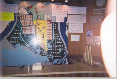
In order to determine who gets to hunt in which zone, a lottery is
held before each of the two daily hunts, held at prescribed times
every day. As the hunters arrive at the area headquarters for the
lottery, they are assigned numbers for the lottery. A random list
of numbers is generated, and the order in which the party numbers
appear on that list is the order in which those parties will choose
their hunting zones. To facilitate this process, a big board is
posted at these areas, and as the zones are chosen, the tag on each
zone on the board is turned over. This is a poorly-flashed photo of
the board at Harsen’s Island:
After choosing their zone, the hunters make their way
to various access points and parking areas that surround the hunting
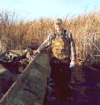
areas. In a place like Harsen’s Island, small boats are
usually used to gain access to the various zones via a
well-maintained system of canals and dikes.
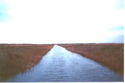
Oftentimes, pure water access is impossible in some
areas, and boats need to be pulled over dikes in order to get from
flooded area to flooded area. Here is a photo taken from a dike
just after our boat has been pulled across.
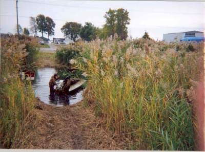
Some of the dikes are quite large, and rollers and
other aids to pulling the boats back and forth are placed on the
dikes.
Depending on the area of the country in which a
specific area may be, the composition of the hunting area can vary
greatly. For example, the Harsen’s Island area is split between
large marsh zones, as seen in the first photo below, and crop fields
which are flooded shortly before the season begins, as seen in the
second photo.
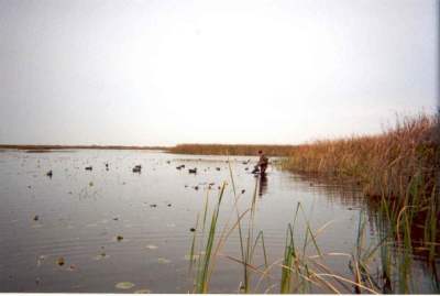
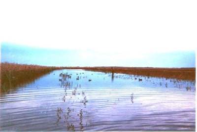
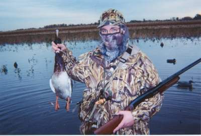
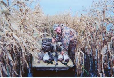
Below are two photos of myself, and you
can see from the background which type of area I’m hunting in each.
The flooded crop fields at Harsen’s Island are
planted with corn (maize) or sorghum. Some of the crop is
knocked-down prior to flooding, while a wide strip down the middle
of the zone is left standing to provide cover for the hunters. Most
public hunting areas also have a refuge area that is planted with
crops or managed in other ways. The refuge area is strictly off
limits to hunters, and provides the often heavily-pressured birds a
place to rest without interference.
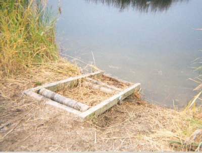
The habitat management of these areas is a year-round
proposition. Oftentimes water levels need to be raised or lowered,
and the area’s system of dikes and canals are utilized to gain
different levels of water in different areas during different parts
of the year. Here is a
photo of some water control devices embedded in a dyke. Shown are
the tops of valves which, when opened, allow the water to flow
freely between the flooded areas on either side of the dyke.

State waterfowl associations and other voluntary
groups often contribute their time and money to improving the area.
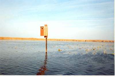
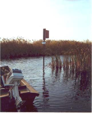
For example, below are photos of woodduck nesting boxes that were
placed throughout the area with the help of the Michigan Duck
Hunters Association. In the second photo, the woodduck box was
built onto one of the poles throughout the area marking the
boundaries between individual hunting zones.
Many hunters often deride these public areas, or just
become so tired of dealing with the hunting pressure that they go
elsewhere. I can’t blame them. Not only does success in a public
area require the same bit of luck concerning the weather and
presence of birds, but additionally getting a good draw at the
lottery is often the crucial factor for success. A high draw means
that one can choose a historically productive zone, while a low draw
will mean taking a zone that is less-favored and will usually
produce less shooting. Hunters often call these areas “duck bingo,”
and the name is deserved. However, these areas provide two very
important things: first, all fowlers have an equal opportunity to
hunt these areas, and do not need access to private land, and
second, the patchwork of federal and state wildlife areas and
refuges provide much needed habitat for the migrating wildfowl. If
one is successful at the duck bingo, and the migration has arrived,
success can often be had at these managed public hunting areas.
Gundog Training Broadsheets
|